Killer descents, murderous climbs

Never underestimate the role of routemaster, especially when your ride-mates are expecting your Exmoor route to double as a pub crawl…
>>> The 100 best mountain bike routes in the UK
Exmoor Killer Loop route directions
1. START. (SS968472) Quay West car park, Minehead
Join trail at end of car park past roundabout. Climb for 0.9km before turning L back on yourself. Continue to junction and take trail directly ahead. At next junction R. Stay on this trail (South West Coast Path) through woodland. R at junction at Burgundy Chapel Clough, continue past Selworthy Beacon and stay on trail to SS910482. L and L following trail downhill before sharp L back down side of hill to Lynch Combe. At head of Combe R down through woodland to Lynch Bridge.
2. (SS900475) Lynch Bridge. Distance so far 9.4K
L at road to Allerford. R at A39 junction. After 200m L on corner of road. Down track turn R into West Luccombe. R at crossroads staying on road up Ley Hill. After 1.5km L onto bridleway then R taking track above woods. L at T junction into woods. Keep on main track and descend down to track next to stream. Cross footbridge and up trail to Stoke Pero. Through farm, L onto road then R at junction continuing on road for 2.9km then L onto bridleway.
3. (SS874411) Wilmersham Common. Distance so far 20.34KM
Stay on main bridleway towards Dunkery Beacon. Once past beacon carry SA to road. Cross road and take trail SA. Continue all the way to Brockwell. Where trail meets road SA to Wootton Courtenay. At junction R through village for 1.25km. Take bridleway L on sweeping right hand corner. Follow fire road round to R and climb up hill. Stay R at first junction then L where trail splits followed by R up to Macmillan Way West trail on edge of forest. L then R at crossroads.
4. (SS949441) Macmillan Way West. Distance so far 31.5KM
Stay on main track down to A39 at Periton Cross. R at A39 then L down Parkhouse Road. SA onto Park St then L onto Blenheim Rd to Quay St. R and back to car park.
Getting there
The route starts from the car park at the end of Quay Street in Minehead (postcode TA24 5U). From the east take the M5 to Bridgewater and then the A39 which runs below Minehead.
Best time to go
While the trails are generally pretty resistant to water there are plenty of exposed sections on this ride, particularly over Dunkery Hill which offers no shelter from wind or rain.
Refreshments
Considering this is the South West this route has embarrassingly few places to find a cream team. The Post Office in Allerford (SS904470) doubles up as a tea room and there is a village store in Wootton Courtenay (SS938433). If you don’t mind leaving the route slightly you’ll find The Horner Tea Garden in Horner (SS898454).
Facilities
Minehead is a reasonably sized town which caters to tourists so you can find hotels, restaurants, fish and chips and supermarkets aplenty.
We stayed at The Old Ship Aground which as well as having good food, beer and incredibly friendly staff also happens to be right at the start and end of the ride.
Exmoor Bike in Minehead is your best bet for spares and repairs.
Other routes
If you’ve travelled all the way to this part of the world you might as well put a day aside to go riding in the Quantocks, just down the road.

Killer descents, murderous climbs
Words and photos: Sim Mainey
Creating a killer
I’m not too ashamed to call myself selfish. Or, maybe it sounds better if I say I’m someone to take full advantage of a situation. So, when I started putting together this Killer Loop series I naturally looked for places I’d either never got round to riding or wanted to go back to. It wasn’t entirely selfish, or so I told myself, I figured that if I was keen to ride somewhere others probably would be too. With the whole of the British Isles to go at I came up with a list of settings for a Killer Loop and near the top of that list was Exmoor.
Exmoor is one of those places I’ve wanted to ride for a while. The promise of sea views, expansive moorland, singletrack through ancient woodland and cream teas on every corner – it all stacks up on paper as an ideal place for a big ride. The reason I haven’t got to Exmoor sooner is down to its location – it’s a long way from my home in The North. When I do venture to the south west I tend to get as far as Bristol before veering west and over the bridge to Wales.
This time though I was on a mission to make it past the lure of the valleys and to find out if the south west is best.
Choosing where to ride is almost the easiest part, putting together a Killer Loop worthy of the name is where the real work happens. Assembling a great ride in places I’ve either never been or only ridden a handful of times takes a fair bit of sleuthing. Maps, satellite imagery, image searches, tapping up local riders for inside knowledge, YouTube videos, the list goes on – anything that gives a hint as to whether one trail is worth including or omitting is investigated. Every junction and variation is sweated over. Sometimes the options become bewildering, sometimes they are obvious, other times I’m left hamstrung by the limited access that mountain bikers have to the countryside. It’s a game of sorts and despite not being particularly competitive I take this game seriously.
Driving down to Exmoor with Rob I have the same old gnawing uncertainty at the back of my mind, anxious that I’ve put together a killer Killer. I’m buoyed by the fact that I’m going to be riding with south west resident, fount of all RockShox knowledge and all-round cheery bloke Tim Flooks. If there was a better route to be had Tim would certainly know it and I could tweak the route accordingly. I sleep well assured that whatever happened we were onto a winner – Tim would see us right.
“No, I don’t really know much of the riding round here. I know the Quantocks like the back of my hand but not so much here. Route looks good though.” says Tim, unloading his bike from the back of his car. Ah. Well that’s that then. “We could always go and ride the Quantocks?” he suggests, obviously picking up on my slight disappointment. I figure we’re here now, we have a route we might as well see how it goes.
Lost in translation
The ride begins in the car park next to Minehead harbour and, naturally, starts with a climb. As the cliff gains altitude from the shore so do we. Dense woodland blocks the view out to sea but the sound of waves below and the taste of salt on our lips let us know it’s not far away. This is the route’s Unique Selling Point, the stand out experience I know will stick in my mind from this ride when everything else has been forgotten. Trails criss-cross the hillside and it takes care to make sure we stay on the right track, follow the planned route and don’t end up back where we started. Despite what he said earlier Tim does actually have a handle on where we are and some of the trails. Mostly from riding up them on his motorbike way back when with girlfriends as pillion. Tim’s knowledge of various car parks, benches and rocks is both vivid, accurate and worrying.

At Horner Woods the trail gets lean, mean and very green
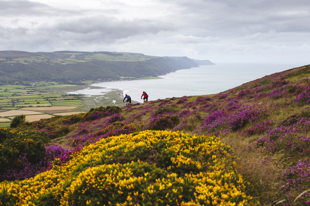
Plotting a route is hard enough, sometimes following it is equally challenging. What looks obvious on the map can be obscure on the ground, unmarked psiren trails tempt us to follow them, looking more attractive than the trail we should be following but ultimately leading nowhere. Tim’s GPS keeps us on the straight and narrow until we emerge from the trees and onto open heathland purple and yellow from the early blooming heather and gorse, looking out to sea the south coast of Wales is seen as a dark blue strip on the horizon. We ride parallel to the steep sided jagged coastline towards Porlock before turning back on ourselves following an easily missed trail along the hillside into a combe and back under the cover of trees. The trail follows the stream that has over millennia created this gouge in the hillside. Twisting and turning enough to keep things interesting while at the same time being well sighted enough to be a point and shoot descent.
Beacon bound
“Who designed this route?” asks Tim, tapping his GPS. I did. “Hm, where’s the pub stop then?” It’s sometimes easy to forget that there’s more to a ride than just riding. While for some a ride is about knocking out A to B in as little time as possible and racking up the KOMs for others it’s as much about the stops at the top of the hill, the chatting on the uphill and, in Tim’s case, the mid-ride beer. I promise Tim a beer when we get back to Minehead. “Well there better be a cream tea stop then.” Er, about that…

Keep to the right track and avoid branching out
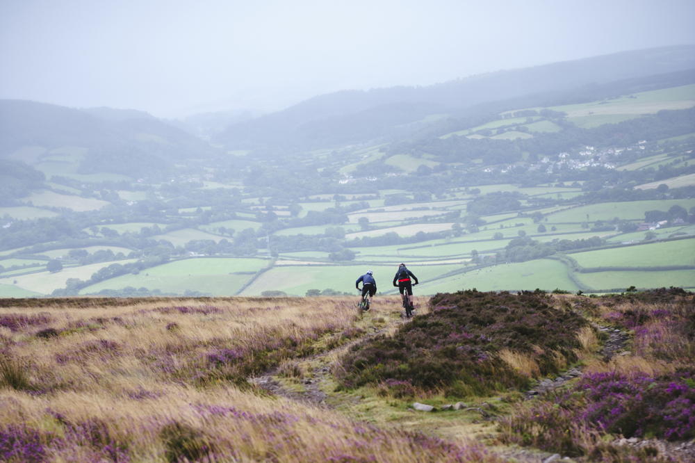
The climb up to Horner Woods isn’t pleasant. It’s one of those climbs that you spend admiring your stem and letting your mind wander to other happier places until it’s over. It is however very efficient at smashing through contour lines and getting us to where we want to be. Peeling off the road and onto the bridleway things level off and open up. We stop for a breather and to survey our surroundings. It’s strangely pleasing to be able to see where we started the ride, the top of the previous descent, where we’re heading and where we’ll finish all from one point. What is less pleasing is the dark grey sky that is a backdrop to where we are heading and the highest point on the ride – Dunkery Beacon. It might clear by the time we get there, we reason, knowing full well that’s very unlikely to be the case.
I’ve been looking forward to this part of the ride. Horner Woods looks, from what I could find online, like it’ll be a lot of fun. Fast singletrack through miniature oak land that gets properly steep in parts. Woodland is always a bit of a navigational challenge, trails created by wildlife can add to the confusion as to which track to take, visual clues as to where you are or where to go can be obscured. We are reliant on the accuracy of our maps, GPS and route plotting to stop us wandering off down a deer track and ending up on the wrong side of the hill.
As routemaster if things go well the best you can hope for is a nod of approval from your riding compatriots, if things go not so well it can descend into full on abuse. Constant needling causes doubts and thoughts of altering the route, to follow what looks like a more tempting trail than the one you’ve marked up. The temptation to deviate can be strong but you have to keep the faith. The problem is when your article of faith, in this case OS mapping, doesn’t match what’s on the ground or where the GPS says you are. According to Southampton’s finest we’re in no man’s land, according to us we’re on the trail. There’s little point in following a trail that exists only in theory so we carry on on the trail that definitely does exist. “You say you designed this route, eh?” No smirking at the back please.
Smirks are soon wiped off faces thanks to the frankly horrible climb back out the other side of the valley we emerge by Stoke Pero church to find we’re in amongst the grey we’d viewed from afar. Up close the grey is unrelenting. Wind drives rain into our faces and on the open moor there’s precious little shelter. A slog up the road in the headwind takes us to the furthest point on the ride. A Land Rover on an ‘Exmoor Wildlife Safari’ drives past us. I wager we’re the strangest wildlife they’ve see today. Three riders, squinting into the rain tacking left and right up the road. We reach the point where we leave the road and join the bridleway. The trail here is, thankfully, easy to navigate – aim for the cairn on the horizon and ride.
Losing my bottle
During my research for this route I found that the view from Dunkery Beacon had been included in the 100 best views in Britain. I’m sure it is, but not today. We don’t hang around too long at the top.
The descent from Dunkery Beacon can be split into three parts. The first section is a reasonably open track fast and rough enough to eject my waterbottle on two occasions, eliciting a decent amount of swearing. This section stops at the road the slices Dunkery Hill in two and continues in a much more rocky and utterly entertaining manner. Line choice and riding light play a part in preventing our wheels taking a proper battering. Tim and Rob tear ahead, trailside heather buffing their shoes and the sound of rock being smashed out of the way in their wake. This descent is properly fast, channels dug across the trail to funnel off water act as kicker jumps sending us skimming down the hill. Things changes as we enter the third and final section – the woods above Brockwell. The rocks disappear but the speed stays high all the way to the bottom.
The final climb of the day takes us up Wootton Common and through forestry plantation. The usual lines of mono-variety evergreens are interspersed with old stone walls and even more ancient looking oaks. It’s heartening that these relics of another time still exist in this place, even if they are hidden away, along with some fun looking trails we spy under the dark canopy of the forest.
Putting together a route is not an easy task. If you’ve ever cracked out a map and a highlighter, used knowledge, guess work and optimism to put together a ride for other to enjoy all credit to you. If you’ve never created your own route and subjected your friends to it, give it a go. Just don’t forget to include the beer and cream tea stops.