 Buy the OS Route Map and instructions for this route
Whilst the tracks and trails of the Dark Peak see more than their fair share of two-wheeled traffic, the western hills – annexed from the main honeypots by a gaping void in the national park boundary – remain relatively unused. Surprising really, as the
terrain is every bit as good: with quick-drying, well-drained trails, plenty of variety, and some rather large hills to grapple with too.
This route scribes a figure-of-eight around this western finger of gritstone hills, nipping into Buxton at the mid-point, should you fancy a refuelling stop. It starts with a long tarmac climb to the head of the Goyt Valley and then hops over the A537 to make a demanding little loop around Macclesfield Forest. The descent into Wildboarclough is an absolute gem – loose in places, stepped in others, and surrounded by some wonderfully wild scenery.
Concessionary bridleways take over as you enter the United Utilities owned forest and duck into the trees. The main descent is a little sterile, but the climb back up again is certainly no walk in the park. Charity Lane is one of the finest downhills in the Peak, but the continuation drop from the Chapel, once a fine technical challenge, has been desecrated by an overdose of sand coloured gravel.
A long road pull leads back into the Goyt Valley, where the climbing continues from Derbyshire Bridge up onto Burbage Edge. Then its rock’n’roll again; all the way into Buxton, followed by a mix of track and lane that leads back north on the eastern flanks of the valley.
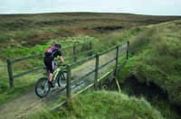
The drop from the road to the river provides the last real action – enjoy that berm. After that, it’s just a steep up, and some undulating farm and forest tracks to the finish.