Back in Black
The Brecon Beacons are a tough proposition at the best of times – add in stormy weather, a late start and a lack of lights and things can start to get hairy.
>>> 100 best mountain bike routes in the UK
Brecon Beacons Killer Loop directions
1. START. (NSO187333) Penrhos
Follow tree lined bridleway, through gate. Ignore gates on left continue on trail L through gorse bushes. Continue up hill on well defined trail with fence to your left. Bear L at top of climb onto grassy plateau. Follow trail past Grwyne Reservoir, continuing down to the road at Blaen-y-cwm.
2. (SO252284) Blaen-y-cwm. Distance so far 8.82KM
SA on road for 2KM, R onto Myndd Du forest road. Follow switchbacks up through forest. Note – logging may be in progress so not all roads may be rideable. At SO245263 L along fire road for 3.8KM. Turn R onto bridleway and continue to forest edge. SA at trail crossing keeping below Crug Mawr. Follow Beacons Way descending down to arm buildings at Draen. Follow bridleway down to road.
3. (SO240211) Draen. Distance so far 22.4KM
R on road then SA for 5.2KM to forest gate at Hermitage Bridge. L then continue through field on track to Tal-y-maes Bridge. Bear R after bridge and follow trail up the valley to cairn at SO204286. At cairn take track R descending to Rhiw Trumau, ignoring bridleway to R. Through gate and down tree lined farm track to road.
4. (SO186289) The Forest. Distance so far 34KM
At road turn R. R at turning. SA to Rhyd-y-car. L onto gravel surfaced bridleway climb. At top bear R following field edge. SA through field joining road at SO184311. SA on road for 2.5KM back to start of loop.
Getting there
While the route starts at the foot of the Y Das climb the road to this point is narrow, badly surfaced and steep. It’s highly advisable to park at the public car park in Talgarth (SO152336, postcode LD3 0PE) and ride to the start of the loop. This adds an extra 10KM to the route but may save the bottom of your car.
Talgarth sits on the junction of the A479 and A4078. From the south take the A40 to CrickHowell and then the A479 north. From the north take the A483 through Wales, joining the A470 at Builth Wells and continuing on the A479 at Llyswen.
Best time to go
This loop takes in proper mountains, so prepare for mountain weather. On a good day this is a great day out but wet weather won’t make it too much of a slog. Visibility can drop severely and with little notice and although the trail is well defined a map and compass are essentials. Allow plenty of time to complete the loop – typically about 5hours.
Refreshments
Once you’ve left Talgarth you’re committed to the loop, there are few options to divert and there are no facilities on the route itself so pack anything you might need – including lights. The Co-op in Talgarth (LD3 0BW) can supply all your trail picnic needs.
Facilities
Drover Cycles in Hay On Wye is the best bet for spares and repairs.
Talgarth has the usual selection of pubs, cafés and kebab shops all within a short walk of each other.
The Dragon’s Back Pub offers camping, bunkhouse and B&B, as well as food and beer making it a good choice as a base for ventures into the Beacons.
For more information on eating and accommodation try www.visittalgarth.co.uk
Other options
Although quite a different prospect BikePark Wales just outside Merthyr Tydfil is 40mins drive from Talgarth. A pay to ride bike park it has a range of trails from blue to black and an uplift.
Words and photos: Sim Mainey
Back in Black
We’re running late. This is the status quo for most rides but this time we’re running dangerously late. Potentially very dangerous. I sit in the back of the van quietly stressing and mentally prepare a selection of contingency plans.
The plan had been that Rob and Rafi would pick me up from my corner of West Yorkshire at 9AM and we’d truck on down to the Brecon Beacons, a four and a bit hour drive, to tap out the route I’d put together for this, the latest Killer Loop. Due to ‘stuff’ 9AM turns into 11AM and the drive is taking longer than planned. By my calculations we’re not going to start the ride until 4.30PM and the ride, without any photo faffery, will take nearly five hours to cover the 40km and 1400m of ascent. Basically we’re screwed.

Let there be light! The curtain of cloud parts at last
A braver and more intelligent man than I would have called it, leant forward from his back seat and said ‘Guys, it’s not going to happen’. But I didn’t, I bit my tongue and employed a strong sense of denial and used badly reckoned man-maths to assure myself that we could get round the loop fine. I also started to wish we had packed lights.
Reassuringly my first prediction is right, we start riding just after 4.30PM. A group of downtrodden looking Duke of Edinburgh participants trudge past us, coming down off the hill after what looks like a pretty brutal day on the top of the Beacons. As their day on the hill was ending ours was only beginning.
Withering looks from Brecon’s four-legged full-timers
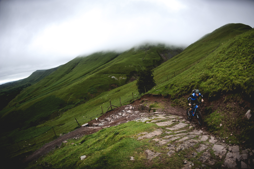
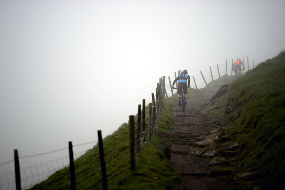
The ascent of Y Das is brutal. It doesn’t mess about when it comes to gaining altitude – straight up with no gentle contouring. It’s also covered in sheep turds, providing a greasy layer on the damp grass and filling our tyres and any other gaps it gets flicked into. We ascend, part riding part pushing further into the cloud that obscures the path ahead. Gliders emerge above us, tracking the edge of hill and the uplift that it provides before vanishing back into the grey. At a distance they are silent but as they pass overhead the roar of wind over wings is surprisingly loud. Further up the valley a bird hovers, a truly silent glider. Visibility is low but the track is thankfully obvious. We stop to catch our breath and look back the way we’ve come. The cloud around us starts to move upwards racing past us at speed and in the space of a few seconds we go from existing in a white, hazy bubble to being able to see the surrounding landscape. The hills opposite are bright but none of that light is making its way over to us, these aren’t called The Black Mountains for nothing. As quickly as the view opened it closes again, a fresh darker cloud sweeping over us.
Time is relative. While I had been stressing about time what I’d really been worrying about was light. It could be whatever time it liked our limiting factor, the thing that we were really racing against, was light not time. Usually on these trips I’ll be constantly thinking about photos, waiting for the right light, and getting riders to repeat sections for the camera. Today I employ a rule of no repeats, no excessive stopping, no waiting. Time after time I race to get a shot to be foiled by cloud moving in to obscure vistas and riders. The pace at which the view changes is furious and infuriating. Today there’s no ‘one more time, please’.
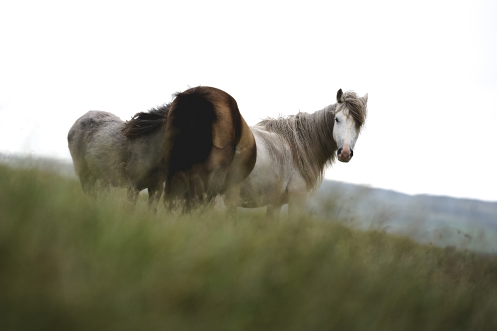
The descent from the top of Y Das to Grwyne reservoir is pretty mellow in attitude, the rutted trail funneling into rocky, fast singletrack pocked with puddles and gotcha pedal-clipping rocks on the edges. Cloud blows in then recedes until we drop far enough below the cloud level that it stops bothering us. A trio of wild ponies huddle together deep in conspiracy, this is their home and they seem surprised to see three mountain bikers on their turf especially at this time of day. Below the Grwyne reservoir the trail becomes less exciting but no slower. Aero tucks and pumping the ground for more speed have us chasing down the valley water streaming from our eyes. The car park at the bottom of the hill is empty and as we hit the road with the forest either side of us it’s obvious that light levels are starting to drop.

Feeling the flow down to Grwyne reservoir
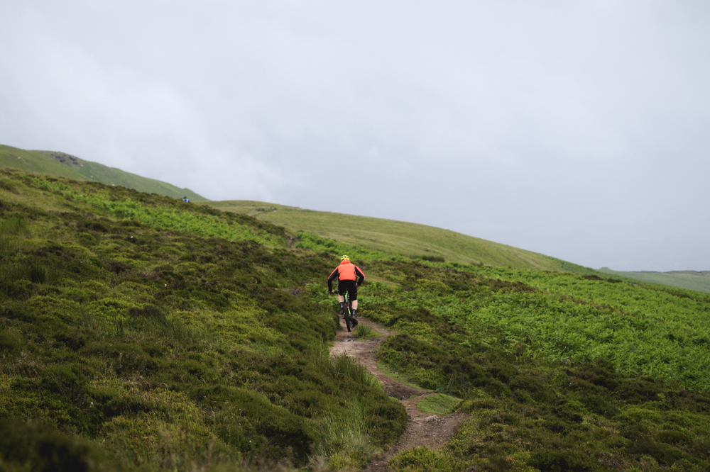
I’ve ridden singletrack vague enough to not really exist, I’ve traipsed across moorland following what a map assures me is a bridleway while being shin deep in peat, but I’ve rarely been as confused and disorientated than when in a Welsh forest. On the map Myndd Du Forest is confusing enough – a knot of fireroads that you’d be forgiven for thinking had been drawn on at random. On the ground it’s no better – a lack of visual clues or discerning features makes placing yourself within the forest a real lesson in orienteering skills. Each junction requires a close examination of map and surroundings. Things are further hindered by this being a working forest and the track we’re looking for is now a hub deep muddy mess covered in pine splinters. We work out our own diversion and continue up the grey and red track between the black and green trees. After much map checking and a reliance on our internal compass’ we top out of the forest onto the open moorland. After the oppressive darkness of the forest it seems light here. Patches of blue expand across the sky and above the cloud-shrouded mountain the sun is managing to sneak a few rays of light through. This is a mixed blessing. While a dramatic sunset and a break from the grey would be very much welcome it also means this is the last gasp before things start to get properly dark. I’ve resisted looking at the time but I’m guessing it’s about 7.30 and we’ve just about reached the halfway point. There’s no point calculating further, I know what’s coming we just need to keep moving.

The grass is always greener on the other side…
The trail that runs from the forest across the fell top and down to the valley is part of the Beacons Way and is a more than suitable reward for the schlep up on the forest road. Tight, flowing and full of lumps, bumps and turns to give you and your bike a proper work out. We stop to take some shots and make the most of potentially the last flicker of light we might see and I manage to lose my camera bag somewhere in the hip high ferns. I spend a good few minutes stomping around swearing aloud looking for a drab green bag in a sea of mid-summer green, wasting valuable time and looking like the idiot I feel I am. Bag located we are now on a mission to follow the sun which has now dropped behind the mountain we need to be on the other side of. The blue patches have gone and we’re going to have to move fast to prevent ourselves being benighted in the middle of nowhere. I consider diverting us onto the road and taking the longer way back around rather than over the mountain but with no lights I’d rather take my chances with an empty fellside than a busy A road.
“Do you know what time it is?” asks Rob, looking at his phone. I’m not sure I want to know after all it won’t make any difference to the fact we’ve got a long climb ahead of us and the dark is starting to make its way down the valley. It turns out it’s 9.30. We pedal on. Each time I get my camera out I boost the sensor sensitivity up two stops, further testing my Nikon’s ability to see in the dark and to pick out riders in the gloom. The climb is steady enough, a gradual grassy track that contours up the flank of the hill before turning back on itself for a brief steep section. I can see the switchback in the distance and despite pedalling for what feels like hours it doesn’t feel like it’s getting any closer. Rob has gone. Head down he’s on a mission to just get to the top, photos and friends be damned. Rafi and I grind on watching the orange dot that is Rob climb into the distance and over the crest of the hill. My legs are beat. Out of necessity the pace of this ride has been much higher than our usual jaunts and it’s starting to take its toll. I console myself with the fact that once we get to the top it’s all downhill back to the van.

Darkness mounts on the Black Mountains
From the top we watch the black cloud roll over a dark landscape. Being the only ones up here and seeing this is a thrill – a show only we are privy to.
Any description of the descent I can offer is based purely on feeling through the bars and pedals rather than what I could see. I ride looking at the trail through the corner of my eye, using the rods in my retina to give me a hint at what I’m riding into. My hands and feet tell me I’m riding on damp grass, rutted from the movement of sheep and water over the countless years. Then rocks, some solid, some loose and clattery giving the impression I’m riding over a trail made of plates. I’m reading the trail like brail, feeling and responding to it at the same time, there’s no chin up, looking ahead and planning there’s only this and now.
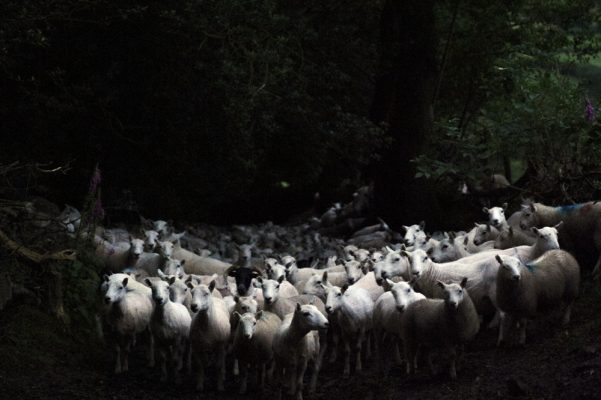
Just when I think it can’t get any darker it does. The trail enters a holloway, lined with elderly hawthorn trees that over their lives have grown together to form a wall and canopy that blocks out all light. Just this final section then we’re onto the road and it’s a quick five kilometre pedal back to the van. We’re stopped by a white line that is moving towards us like a wave. A wave of wool. Our path is blocked by a farm’s worth of sheep being driven up the hill for the night. The noise is incredible, a hundred or so animals all bleeting and marching together. We’re forced to throw ourselves over a fence and stand aside to allow them past before we can go any further.

Surfing loose rocks in fading light calls for Jedi-like skills
The five kilometer pedal on the road is barely that. A gravel climb, a plod across a field and tight farm roads make up most of it. We arrive back at the van at 10.30PM, tired, hungry and covered in sheep dung. Rob fishes a can of lager out from the back of the van and we take it turns to take a gulp. It’s the best crap lager I’ve ever tasted.

“There’s my camera bag… no… there’s my camera bag…”
There are probably a whole host of lessons to be learned from our mis-adventure, I’m still working them all out. I’m not particularly proud of our piss-poor planning and there’s plenty I’d have done differently, but it’s a story for the pub and a ride to remember – after all good memories can be made with bad decisions.

“Anyone for beer? I’ll take that as a no”
A note of caution
If you’re planning on tackling this route, or indeed any route beyond a quick spin around your usual trails then this checklist for a big day in the mountains is well worth a read.
Riding in the mountains is serious business and despite being a bit daft in setting off so late we were properly prepared for what we were up against – although lights would definitely have been a good idea in retrospect.