Highland sting

Head to the Highlands and get swept away by Torridon’s torrent of untamed trails; just watch out for the flesh-eating midges…
>>> Download all of our free routes for Torridon, Scotland
Above my desk, on the second shelf up, next to a stack of maps, sits a large triangular stone of white, pink and orange hues. I picked that stone up 10 years ago on a camping holiday with my dad and brother. We had driven past an imposing mountain high up in the Scottish highlands, a couple of miles from the village of Torridon. Its distinctive bright slopes of shattered quartzite, and triangular shapes somehow to drew me to it.
The next time past I got my dad to drop me off at its foot and while he and my brother went off for the day, I started the steep scramble up to the summit. Half way up crossing a scree slope I saw this triangular rock layered with colour and picked it up for no particular reason.
Up on the summit I had the mountain to myself, the knife edge ridges of Beinn Eighe stretched out before me, with the triple buttresses forming the shape of an E, I sat down on the middle ridge with a vast valley dropping away either side, and munched my lunch in silence watching the shadows of clouds drift across the landscape. Twisting, well defined ribbons sprawled across the rocky valley floors, were these trails or rivers? Either way they looked bizarrely clean and smooth, perhaps smooth enough to ride bikes along? Not today though. With no mobile phone, I was relying on meeting my dad at a certain time back at the bottom of the mountain. I tore myself away from the view but vowed to someday return.
A decade later and I’m on the road, venturing past the access road to the Fort William world cup downhill track, and then 2 hours north. Now I’ve heard of Torridon in a mountain biking context for years now, and only ever good things have been spoken, well, other than the distance. Hailing from the South East of England, Torridon is a bit of a trek! Geneva is a shorter drive.
I’m making the trip up with Toby Pantling, who’s been there once before, and with our combined limited knowledge of the area – we’ve got three days to get out and see what we find.

Hike-a-bike extreme: negotiating Torridon’s watery chasms
Our only real form of guidance is a trail from Achnashellach, heading North. It’s the one trail Toby has ridden up here and beyond that, we’re on our own.
There are various guiding companies who offer their valuable knowledge and experience to make the most of the area, but for some reason, possibily stupidity, we opt out, and go old school with a big paper map and a hostel booked for the night. Parked up at the bottom of the trail, I hop out the van to get that map from the back and ahh… midges. It’s June; prime midge season, and in this sheltered wooded spot they are out in force. Diving back into the cab we spread open the map and trace the route of this trail whilst randomly clapping and slapping our heads free the midges.
Midge ire
It climbs up to a high valley, where a crossroads with unknown trails to the left, ahead and to the right that are crying out to be explored. With options there, we sit for 10 minutes planning exactly what kit we need to put on, where it is in the van, and the minimum bike fettling we can get away with to limit our exposure time to the midges. We swing the doors open and all hell breaks loose, van doors open and slam, bikes get pulled out, we swat the air, swat our faces, and swat out legs, we’re changed in record time, all interspersed with a few high speed walking intervals to try and shake off the midges before hopping on our bikes and getting riding. If you’ve never experienced Scottish midges out in full force, I’m warning you – they’re something else…

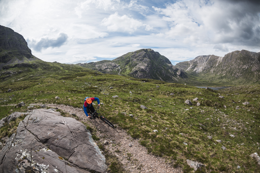
Ploughing a furrow through Torridon’s craggiest pastures
Out of the woods and the landscape is our own, patches of sunlight pass across our two tiny figures dwarfed by the scenery, it’s a mix of riding and pushing, but seeing such good trail conditions, I can already tell any hike-a-bike is going to be worth it! The ground is hard packed, with a mix of eroded Torridonian sandstone that creates a hard but well drained surface, and moonscape slabs of exposed rock, all just begging to be ridden.
It’s not too long before we hit the crossroads, ahead looks like a pretty epic descent traversing the side of this valley down towards us with scale hard to judge, to the right, the trail goes looks flat and vague, to the left a promising two foot wide twists off into the distance, teasing us to it’s destination. We’ve not got ages, so we save the big descent ahead, and instead peel left and follow the singletrack down, across a river before heading up, again a mix of riding and pushing.
We keep following it up until the up becomes a down but hold back letting gravity take us forward. In front of us is a deep valley, with rivers and paths winding their way along the floor. One path on the opposite slope looks immaculate and smooth, with regular hairpins zig zagging up the valley side. Pulling out the map, we pick it out, and plot how to get to get there and then how to get out of there. A logical route springs from the map; up along the valley below us past a bothy, then kick up the steep hairpin climb into this high zone, looping around a mountain, past a loch and back into the original valley before a climb and traverse taking us up into the start of the epic descent behind us. After scanning the map, we look up at the scenery around, and below us. We’re high enough to trace that route around the scenery in front of us like we’re plotting a route on google earth. It looks a big day out, 40k in this scenery is a solid ride!

Cloud-smudged peaks and verdant valleys are made for adventure
The following day, with the weather looking fairly grey, we pedal up the first section of the ride; it follows a river up the valley, but stays mostly ridable. It takes longer than we thought, so when a bothy appear ahead, we take the opportunity to get out of the slight rain, explore it’s rooms, munch on some lunch and have a quick brew before plodding on.
The next section is that super smooth hairpin track we could see across the valley, although it turns out it’s pretty steep, and that smoothness was just an optical illusion from the uniformly colour rocks… No riding here, just a long hike-a-bike where conversation trickles dry and all that can be heard is a plaintive howl from the wind blowing over the stealth cable routing hole on my downtube, and the static crackle of rain on our jackets.
It’s a long climb, but we’re glad we approached it this way around, as a descent it would be pretty loose. Over the first of 5 saddles of the day and into the high area which is a complete unknown to us, the path on the map could be anything, it could be a bog, or non existent, but instead a long defined single track stretches out before us while the mountains beside proceed on up into the mist.
We pile in clattering over loose rocks railing turns as much as we dare. Gradually the singletrack turns uphill as we circle a mountain and pass a low saddle to reach a picturesque loch with miniature islands dotted about its surface. Across the water, a few fellow mountain bikers navigate their own stretch of foot wide heaven, and I thought we were the only ones? Their bright colours and mechanical mules look somewhat out of place; primeval landscape or big mountain bike park? I wonder how this area has built such a name for itself. In part it seems down to the number of paths that are actually ridable, especially considering the remote setting. Of course there are hike a bike sections and some are not short, but every time the bike gets hitched up onto the shoulders, the gravity fed reward is more than worth it.

Handmade signs point the way to civilisation
Towards the top of the next saddle, and we see a path disappear off to the left, we spotted this on a map earlier, it looks like it links up to a path finishing not far from Torridon village. It’s so tempting to take it purely to see where it goes, but that’s for another day, today we’re feeling it in our legs. After the fourth saddle, we reach a new valley which feels so far removed from where we started. The weather is closing in and it’s getting to that point where the ever diminishing energy levels are starting to drop off a cliff.
Best for last
Some flat singletrack leads us to the last, and highest saddle of the day at just over 680m. As is always the case, the last proper bit of climbing, is also the steepest, and with tired legs; the hardest. With an effort we top out, feeling like we have to duck our heads below the thick blanket of cloud smothering the surrounding summits. We shelter behind some rocks from the wind and rain in this monochrome world.
We dig through our packs looking for anything that might contain calories, luckily we have some emergency jelly babies to help power us along the final stretch. I never knew I liked jelly babies so much!
Onwards, and as home straights go, do they honestly get any better than this 7km stretch laid out before us? Not that it’s a straight, nor that it leads home. With what feels like a storm bearing down on our shoulders and pressing us into the descent, Toby takes the lead into this rollercoaster of singletrack, from the saddle it negotiates a small loch before crossing sides over sketchy rock gardens, over crests and through compressions as we traverse the valley side on this truly three dimensional trail. The gradient eases for a while before taking us to the moonscape area we pushed up a few days before, bright rock slabs litter the area, some providing kickers and landings for when we have the energy. The trail flows and we outrun the impending storm. Suddenly we’re on an enduro race stage as we follow each other on max attack making use of our final reserves of energy before crossing the finish.

A bothy’s the best way to get warm in a shot
After just one afternoon and one day, it feel like the drive up from the South has easily been worth it, the scenery alone in the area is so stunning, and to have such amazing trails threading their way around the mountains, is so rare. If you were on a tight schedule it could well be worth speaking to one of the guiding companies, or go your own way, buy a map, do some research online and take a bit of a gamble. If you can dodge the midges and the rain, you’ll have one of the best mountain bike experiences in the world.