The singletrack and the tranquillity of this beautiful and intimate valley are unrivalled

With National Parks to the north, south and west, it’s all too easy to overlook Mid Wales, but Doethie Valley offers ample reward for heading into the hinterland.
>>> The 100 best mountain bike routes in the UK
Making Doethie Valley our trail of the year back in 2011 was a tough call. It’s a mission to get to, two-thirds of the loop is on double-track and it seems to be suffering under the volume of traffic and notorious Cambrian weather. But… well, read on.
The missing link
Words & photos: Sim Mainey
Have you ever heard of an area of freshly logged Amazonian rainforest described as being the size of England, or a melting arctic ice shelf equated to the area of Northern Ireland? You probably haven’t because for some reason the country used as a standard unit of measurement is Wales. Why this is I’m not really sure. Maybe it’s because it has parallel coastlines at either end making it easy to gauge on a map and in the mind. It could be because it sits conveniently halfway on the British Isles land mass scale – smaller than Scotland but bigger than the Isle Of Man. A more likely reason is because most people don’t actually have a clue how big Wales really is but feel like they ought to, allowing it to be used as a vague description of something pretty damn huge. The other possibility is that natural disasters just happen to be about that size, which doesn’t bode well for Wales in the long term.
Whatever the reason it’s taken as a given that we know how big Wales is but what is contained within still remains a bit of a mystery to most. To those living outside Wales much of our Welsh geographic knowledge is framed by its three National Parks – Snowdonia in the north, Pembrokeshire on the south west coast and the Brecon Beacons in the south east. The area between these, mid-Wales, is a little bit of a no-man’s land to most. Here be dragons.

Mid-Wales is a little bit of a no-man’s land to most
While the trio of national parks may draw in the crowds mid-Wales seems a little aloof, no less beautiful in its own way but with the feel that this is very much a place of work with commercial forestry, reservoirs and sheep as far as the eye can see. It was here that Wales’ fourth National Park was proposed. The Cambrian Mountains National Park was to stretch from just below Machynlleth in the north to Llandovery in the south, spanning the area between Snowdonia and the Brecon Beacons.
Originally proposed in 1965 it took a decade for the idea to be officially killed off by the then Secretary of State Peter Thomas, citing ‘massive evidence of objections’. Those objections had come from county, district and parish councils, landowners, farmers, farming unions and more – presumably all unwilling to relinquish power to a new National Park authority. In the end only three letters of support for the park were received – those from the Ramblers’ Association, Youth Hostel Association and the Cyclists’ Touring Club. A public inquiry into the rejection of the park’s designation was also ruled out by Thomas on the grounds that “I cannot envisage any evidence which would lead me to change my mind”.

Toppled trees prove you’re off the beaten track
History has a horrible habit of repeating itself. In 2015 the Welsh Government opened up a consultation into reforms that would lead to Wales adopting a Scottish style of countryside access, opening up thousands of miles of trails that are off-limits to mountain bikers.
Park strife
Despite overwhelmingly positive support from various cycling organisations (including the CTC’s descendent Cycling UK) and thousands of riders it’s taken only three years for the consultation to be shelved, like that of the Cambrian National Park. Welsh Minister for Environment Hannah Blythyn said: “There were strong but differing views on how best to reform access legislation. We therefore believe that now is not the right time for substantive reform.” It’s going to take a while to unpackage the real reasons behind this rather depressing decision but it’s hard to think that they are any different to those behind the snubbing of the Cambrian Mountain National Park.

This singletrack has earned its place in the pantheon of the greats
A quick scan of a map of mid-Wales might have you thinking that the lack of open access is not such a big deal – after all there are plenty of bridleways criss-crossing the area. But not all bridleways are created equal and the majority of dashed lines in this part of the country are wide and gravelly, more access road for industry than escape routes for recreation. There are exceptions though and tucked away in what would have been the Mid Wales National Park is one of the finest bridleways in the country, the Doethie Valley.
Crowned MBR Trail Of The Year in 2011 and included in our Britain’s Best Singletrack guide it’s fair to say that this remote piece of singletrack has earned its place in the pantheon of trail greats. Its quality and rarity make it a magnet for riders looking for the best that mid-Wales has to offer so it seemed a fitting place to go and ride in the National Park that never was.
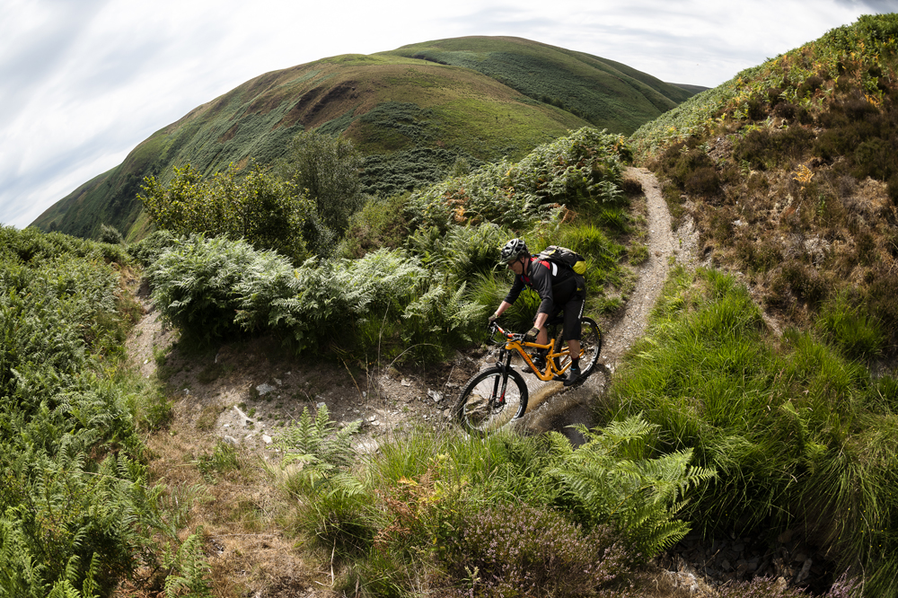
Bracken-fringed switchbacks scythe through a sea of green
After much back lane driving that pushes our faith in the sanity of satellite navigation Dave and I pull into the carpark next to the alarmingly empty Llyn Brianne reservoir. Its steep stratad sides like the rings of a tree tell the tale of a summer of endless sun. Despite its remote location there are plenty of sightseers and picnickers ogling what’s left of the lake. We peer over the dam wall to the trickle of water below before making our way onto the yellow gravel road and into the forest.
Timber wagons and Forestry Commission pickups clatter past us on the fire road, creating plumes of dust that leave us choking in their wake and reminding us this is very much worksite rather than playground. Scenic as it is here it’s not the picture of rural idyll that you might associate with a national park.
Skirting the edge of the reservoir we gradually climb on monotonous fire road until our route breaks us out of the shade of the forest and onto the open the parched uplands.

Lichen the post, lovin’ the trail
While our National Parks are much loved they aren’t always positives. Restrictions on what can and can’t be done to property and land, inflated house prices, increased pressures on wildlife, public services and infrastructure are all downsides for those who live within a Park’s boundaries. Living in what feels like a museum is not much fun so it’s understandable why there might have been objections.
Opening up access to all is not without downsides either which is why the Scottish Outdoor Access Code exists, making sure countryside users know that while they have a right to roam it comes with the expectation of responsibility, respect and care for the environment. As riders we understandably, or selfishly, want as many trails open to us as possible. In some places the impact of more riders would be minimal, in others it would be massive, both positively and negatively. It’s hard to think that in Wales, with its low population density, reliance on tourism and such fantastic terrain, open access would be anything but a positive.

Some bridleways have tempting off-piste diversions
Our route is easy to navigate and there’s little risk of losing our way or venturing off the track thanks to barbed wire lining the way. Every gate we come to is padlocked, adding to the feeling of inhospitality to visitors – woe betide your back if you’re on an e-bike, some of those gates are pretty high.
Sweet valley high
A rather sad looking stretch of bridleway breaks away from the gravel road and cuts down the hill. When it was last used I don’t know, but a sorry looking wooden gate and no defined trail hint that not much traffic has passed this way recently and this bridleway now exists more in theory than reality. Have potentially interesting trails like this fallen from use as riders have given up trying to find the good stuff in amongst the dross, got fed up with the hassle of dealing with locked gates, boring surfaces and a general feeling of not being welcome and taken to trail centres instead? Is it just us determined and bloody minded sorts who are willing to deal with the hassle to get to the rewards?

Undulating unspoilt singletrack offers blissful solitude
A steep climb covered in loose clattery rock and more suited to four driven wheels has us off and pushing our bikes while looking for fossils in the broken stones and basking adders by the edges of the track. From the top we are treated to landskein – layers of horizontal hilltops fading from green to blue in the haze, all full of promise and potential. This landscape may lend itself to Grade-A mountain biking but the reality is it’s more likely to be graded, limited and ultimately frustrating. Things are no better for walkers, there are suspiciously few footpaths in this neck of the woods – if the proposed land reforms had opened up footpaths to mountain bikers I’m not sure there’d be any more to go at round here.
We reach the head of the valley and the start of the trail we’ve travelled all this way to ride. The signpost for the bridleway is a simple lichen covered wooden arrow devoid of any information. It feels as unwelcoming and unhelpful as the locked gates. Being mid-summer the bracken is well above handlebar height obscuring the trail below and encouraging riding by feel coupled with absolute faith in suspension forks and reflexes to deal with what lies beneath. The valley is a beautiful u-pipe of green cut through the middle with the sandy scar of where the Afon Doethie normally flows. Wild horses high above us are our only company but tyre tracks in the dirt tell of riders having passed this way earlier. If this were a National Park would it be any busier? I doubt it. There’s a level of commitment required to get here that is enough to keep things the right side of quiet.
What makes this trail so unique for the area is that it is entirely ungroomed singletrack. There are no sections that widen out, taper off or feel tamed. It’s the real deal – the perfect trail. What makes it even more special is the way it weaves so many textures into the riding experience. Flickering bright green bracken is suddenly cut through with purple bursts of heather. Lone silver birch and oak trees counter the blocks of omni-evergreen forest on the top of the hill. The trail changes from baked dirt to loose slate to rock slabs. It flits between arrow straight to switchbacked corners, high Alpine meadow through to stream crossings. You never stop being surprised.
A fallen tree blocks our way and stops the natural rhythm. In some ways it’s quite heartening – proving that this gem of a trail is unbothered and immune from meddling or repair, well intentioned or otherwise.
The sun is starting to dip behind the hills and we’re both out of water, with no cafés on the route we’re entirely self sufficient and our sufficiency is now low. The valley trail finishes with a crescendo and dumps us back onto familiar wide access track. It feels like a jolt back to reality and after the highs of the valley trail it’s even harder to cope with the struggle back up the hill to the reservoir. The car park is now empty apart from a few camper vans making the place home for the night.
It’s hard to say how much National Park status would have changed this area. Would it have brought in more tourists and their much needed money but in turn created more problems or would it have had any effect on visitor numbers at all? The same goes for open access. While undeniably a great thing for mountain bikers, and Wales in general, part of me can’t help thinking that mid-Wales, for better or worse, is immune and unwilling to change.