Put the mountain into your mountain biking – the easy way!
Big mountain adventures with a small ‘a’ – less hike-a-bike, more trail to like. Five routes that put the mountain into mountain biking – the easy way.
>>> 20 best mountain bike trails in the UK
We all love mountains. But by definition they can be hard work: big climbs, lots of carrying and super-techie descents that could leave you wondering why you went to the trouble in the first place. This little collection swings the balance. OK, they aren’t all super-easy – things just don’t work that way in the mountains. But we think they go some way to bringing the mountain to us.
1. The Gap, Brecon Beacons
33km/20 miles
Ride time 3-4 hours
Why ride it? Total classic – never that hard
Where to eat? The Star is awesome
A legendary mountain route and with good reason – the ambience of the 600m Gap is worth every bit of pain on the climb up. But it’s never that tough, with just one very short hike-a-bike on the whole route. From Talybont-on-Usk (Landranger 161/SO114225), follow the Taff Trail S then W to the road at Torpantau. Turn L then first L (Taff Trail), then keep R to the road. Turn R and R again to follow the Gap Road to the Gap. And keep SA to drop to the road head. Take a narrow track on the R, NE to a x-roads and then turn R to follow lanes and BWs to Llanfrynach. More lanes SE to Pencelli, then the Canal to the finish.
2. The Garburn Pass, Lake District
16km/10 miles
Ride time 2-3 hours
Why ride it? Big mountain feel without the big mountain commitment
Where to eat? The Watermill or Ambio Café!
At a modest 450m, the Garburn Pass probably would make the technical cut for a mountain route. But it feels like one, and that’s what concerns us here. And the descent to Kentmere is as much fun as you’ll have anywhere in the Lakes. From Ings (Landranger90/SD444987) climb NW on lanes to High Borrans. A track then takes you N past Dubbs Reservoir and joins the Garburn Pass. Climb NE over the pass and drop to Kentmere. Take the BW S from Kentmere Hall and follow it all the way to Grassgarth, where a lane drops you back to Ings.
3. Conic Hill, Loch Lomond
16km/10 Miles
Ride time 2-3 hours
Why ride it? Small hill, big feel, wicked technical descent.
Where to eat? The Oak Tree Inn or Village Shop Cafe in Balmaha
Conic Hill is just 361m at its summit. And we’re not going there! Though it’s easy to do so if you wish. But it’s also a peachey little mountain, surrounded by giants and overlooking Loch Lomond. From the Garadhban car park (Landranger 56/NS479906), take the West Highland Way NW through the forest and fork R to emerge onto open hillside (NS451920). Climb N then W around the flanks of the main act. Then stay with it as it loops around the SW tip of the mountain in a series of steep steps and rock gardens that plummet you into the trees at Balmaha. Take the road E to Milton of Buchanan and then fork L, back into the forest, to rejoin the WHW and follow it back.
4. Mam Tor, Peak District
14km/8 Miles
Ride time 2-3 hours
Why ride it? Awesome ridge top ride with easy access
Where to eat? Old Nag’s Head, Edale
At 517m, Mam Tor is no giant. But it punches above its weight, as the A6187 found out. The remains of which provide the opening fun on this great little 2 up, 2 down that loops around the shapely Derbyshire peak. Start from the bottom of Winnat’s Pass (Landranger 110/SK143828) and follow the Mam Tor Road W then N to the road end. Continue on the contorted tarmac to join the road again and turn R and R to climb into the saddle beneath the hill, then take the BW NE to Hollins Cross. Descend NE to the road. Take this L into the village, then climb out S to Greenlands and E back to Hollins Cross. Now descend SE to Castleton.
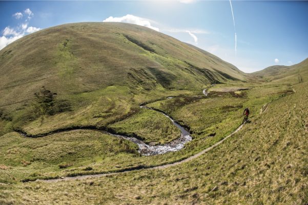
5. The Calf, Howgill Fells
16km/10 Miles
Ride time 2-3 hours
Why ride it? What a summit!
Where to eat? Red Lion, Sedbergh
A seriously big hill but barely a rock to be seen. OK, it’s not exactly easy – it’s a big push to get up to that 676m summit, but it’s worth it for the super-cruisey top section and the full-pelt dash back down. From Sedbergh (Landranger 97/659922) take the lane NW beneath Height of Winder, then N to the drive of Birkhaw. Take this then the BW that trends NE around the hillside and drops to Bram Rigg Beck. Keep SA up onto the ridge and follow this to the summit. The Calf summit is a few metres to the L. Head SE to Calders and then plummet down the grassy BW into Rowantree Grains. Climb then drop again, now fork R to climb around Winder and drop steeply to the lane you started on.