 Buy the OS Route Map and instructions for this route
Linking the two H’s: Horton and Hawes, seems an obvious mtb challenge, especially considering the amount of tracks and trails that span the lofty hills that separate the two. But sadly, up until recently, most of these routes have been out of bounds to two wheels, so the loop’s never become the classic it deserves to be. This is all about to change though, and the footpaths that previously prevented a continuous off-road link south from Hawes are in the process of being upgraded, making it possible to ride them legally for the first time. This route makes the most of the new situation.
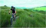
Horton is hemmed in on all sides by typical Dales walled tracks, so it’s little surprise that the opening climb takes one of them. The walls quickly recede into the hillsides and an open track strikes out across Low Birkwith Moor towards the forestry at High Green Field. Tarmac takes over for the pull up onto the Cam High Road, but I don’t think anyone’ll be complaining too much: this is a big climb. Another rocky track continues the ascent to a high point just short of 600m, and then grassy moorland singletrack leads sweetly out onto the edge overlooking Wensleydale. A rough and rubbly descent provides the challenging drop into Hawes.
The grassy climb/push out of Gayle is the least rewarding section of the whole route, but from the top, the going gets better and better, and the views are something else. It’s Pennine Way all the way now, first on the West Cam Road, and then on the previously mentioned Cam High Road, both originally of Roman construction, and both superb tracks to ride. It’s not quite downhill all the way but with over 350m in the bag, it might as well be. Enjoy.