 Christmas Trails
I’ve been living in London since May, having moved here from Oz. Myself and a couple of buddies don’t want to hang around in London over Christmas while everyone else is spending time with family so we’ve been thinking about hiring a cottage somewhere nice and getting some riding in. We’ve not really seen much of the UK yet so we’re all up for travelling. All we really care about is getting somewhere where the riding’s good, and the pubs won’t mind some drunken Aussie blokes propping up the bar into the wee hours!
Bruce, Earls Court
Good shout! And so much better than cold turkey and Queen’s speeches. If you fancy some natural stuff, head for the Quantock Hills — see the route in this month’s issue — for good, well-drained trails and milder south-west weather. Or if you prefer some waymarked trails, probably best to head for Wales, where the climate will almost certainly be milder than Scotland.
We’d suggest Coed y Brenin as a starter, as there are loads of trails and plenty of accommodation in the area (check out the ads in the back of magazine). It’s also not too far to travel from here to Gwydyr or even Nant yr Arian.
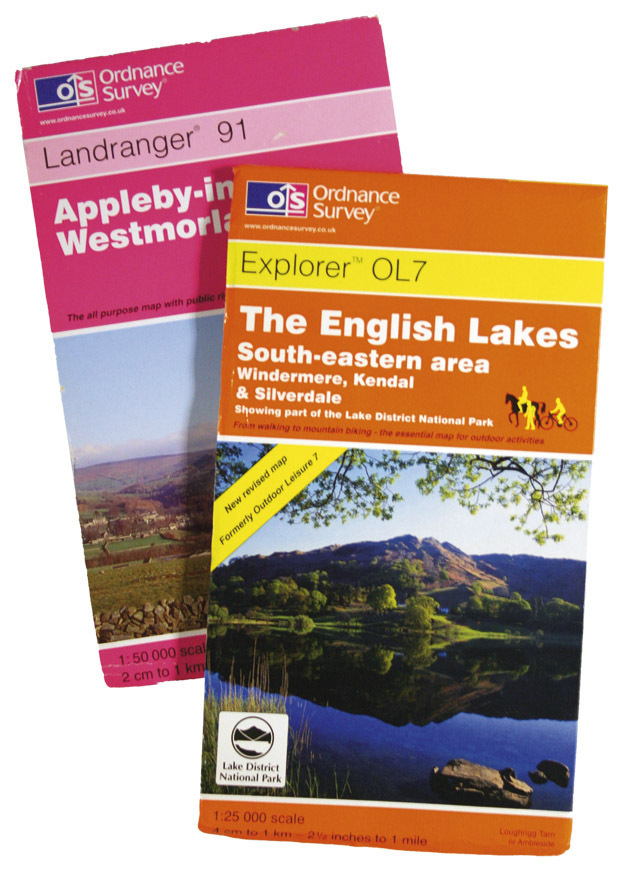
Which map?
Settle an argument for us — what’s better, OS 1:25,000 or
OS 1:50,000? My mate says 1:25,000, I say 1:50,000 — who’s right?
Garth Vader, Solihull
Unless you are travelling huge distances, where the sheer amount of maps you’d need started to get out of hand, I’d say 1:25,000 every time. The extra information makes it so much easier to locate yourself. If you’re following our pull-out routes, I’d use the pullout
1:50,000 as the main map — especially as it has a few instructions on it too — but carry the 1:25,000 in case things go pear-shaped.
Location, location
My husband has hinted quite strongly that he’d like a GPS unit for Christmas. We’ve not used one before so I could use some advice. What accessories will I need? Are things like handlebar brackets included?
Terri Bowles, Blackpool
It’s difficult to answer this one without endorsing particular models but it’s worth remembering that things are changing all the time. We use Garmin units — both Vista Cx and GPSMAP 60 Cx — and they work brilliantly bar mounted. The main things for us are easy PC compatibility to download routes, and a clear navigation screen to make it easy to read when belting along the trail. The handlebar brackets etc are usually extra, but essential to get the most out of the unit. You may be able to negotiate a deal including one if you’re lucky.
Trossach Trails
I have just booked a getaway to the Trossachs at the end of September and can’t find any Ride Guides in past issues of mbr!
Just wondered if you had any recommendations with regard to trails I should have a crack at locally?
Tony Bell, email
Firstly, sorry for the late reply: we passed this one over to our Scottish correspondent Macca, who lives in that neck of the woods, and he was rather busy at the time of your trip. Hopefully you found some great rides anyway. Andy suggested starting in the Dounans Centre in Aberfoyle, and heading east round the edge of the forest, before turning north-east on singletrack over the Menteith Hills. Continue past the lochan and bear right onto a fire road, then immediately left onto a techie descent to Loch Venechar, which you skirt before following the Forest Drive back to Aberfoyle. He also suggested that as you start to go downhill, you should keep a sharp eye open for some singletrack descents.
Another alternative is to take a spin up the West Highland Way over Conic Hill (by Loch Lomond) for a stiff climb and technical descent, or just follow The WHW up Loch Lomondside to Inversnaid and return via the singletrack roads and fire roads.
For other ideas north of the border, check out Bike Scotland Trails Guide by Andy McCandlish and Richard Moore, published by Pocket Mountains Limited.